Nassarid Gazeteer
Regional Map
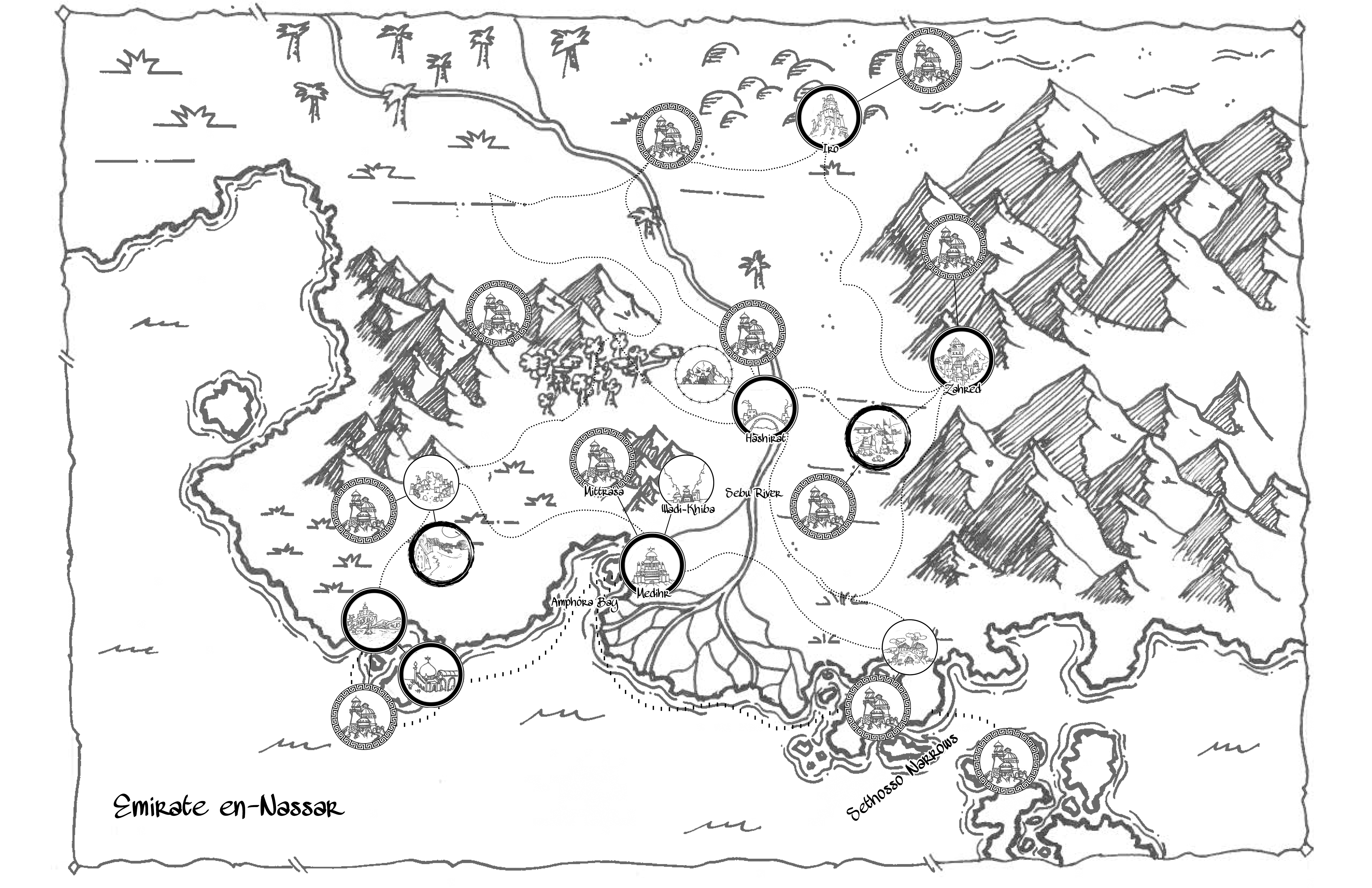
Zahred A trade city that sprung up on the Nassarid side of the Ashvale pass. In ancient times, this was a network of slave pens for the construction of the Valley of Kings. In the modern day, it is a once-thriving city that is seeing hard times with the new embargo the Khazramar have place on travel along the pass.
Iro A keep on the borderlands of the emirate. Wedged between the Ammadid Emirate and the Deep Desert, the citizens here have grown accustomed to a hard life. Recently, however, the soldiers stationed within have been reporting more activity from the desert than usual.
Sebu River The lifeblood of the sultanate, the Sebu River cuts across all of western Rumahl and provides an arable region even in the harshest lands. The seasonal flooding of the river is both predictable and vital for the deposition of nutrients into the soil. Medihr is seated at the mouth of this river at the Sebu Delta opening into the sea.
Ashvale Pass The only land route between east and west Rumahl. Official trade through this path is more or less stopped due to an embargo by the Khazramar and a reciprocal punitive tariff imposed by the Nassrid. Still a common path for smuggling, without large caravans with security sponsored by wealthy merchants, the hills have become home to many bandits and ne'erdowells again.
Amphora Bay The bay upon which Medhir is situated. So named because of the way the water turned the color of red wine for many years during harvest season as the massive butchers' guilds simply dumped their waste blood into the drainage system.
Sethosso Sea The sea to the south of Medhir and the main method of travel and trade with east Rumahl with the land route closed. Dangerous due to not only the many corsairs and Tahoan raiders that make their home here, but also due to strong winds and the many small islands of the Sethosso Narrows. Many trade vessels have found their final repose here and few have ever been recovered.
Medhir
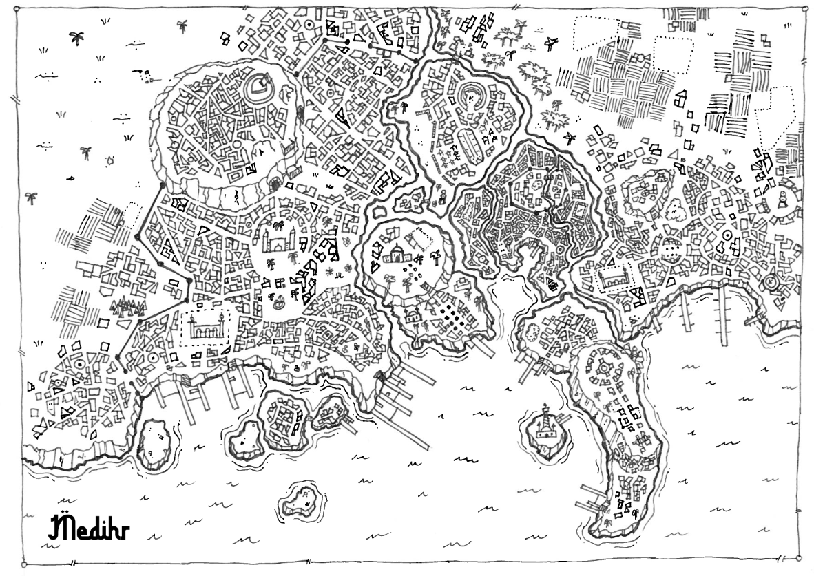
Overview The capital city of the Nassarid Emirate and the largest trade city in western (and possibly all of) Rumahl. This massive megacity is nearly 30 miles across and has long outgrown its original borders. Due to some interesting civil engineering, the city is able to exist on a series of canals from an off-shoot of the Sebu River without being damaged by the annual floods.
Emircrest The royal district, often simply called The Palace. Home to the palace of the emir as well as the main mosque of the Tribunal and a major temple to the Old Gods.
Bayside The nobles district. It is situated upon a seawall plateau, with amazing views of the surrounding area. The nearby hillside and lowlands are a much poorer area, home to many of the servants and support personnel. Its location on the coast puts these lowlands in the direct path of any military forces or typhoons that hit the region.
Oldtown The original extent of Medhir. It is now the most densely packed district in the city. It is also the only area that is still almost entirely built upon a network of canals with few streets on land.
University District An upper middle class district that is mainly known for the Madrasa al'Rhaim.
Roachwing A shantytown just outside the western gates to the city full of undesirables. Nobles, and therefore law enforcement, rarely bother traveling to this district.
Brassdock A lower middle class district that has many blue collar workers and is home to the main import/export docks in Amphora Bay. Also has a large garrison for emirate troops on the western side of the river.
Riverside Many guild headquarters are built here in this mostly nondescript district. Has as much land outside the city walls as within.
Northgate Home of the main bridge for land travel into the city as well as the Great Bazaar that takes up nearly half of the district. Contains the ruins of the old coliseum that was once used for slave fighting during the times of the Galoran Empire.
East End The breadbasket of the city, with many farms and other rural establishments. Also contains a garrison for the eastern side of the river
Whitewall A small district located just across the canal from the emir's palace with ample dock space for foreign visitors to land and get lodging. The great mosque to Ish Arum, built into a massive lighthouse, is located here as well.
Highmont Located atop a towering plateau in the northwest corner of the city, this district is a hotbed of technological research. Many alchemists and artificers have their labs and workshops here, which helps keep them secluded from traditionalists who may hamper their work, but also concentrates the pollution put out by their experimentation.
The Undercity Not a true district, but there are many who have no choice but to set up their homes in the dank underground tunnels beneath the city.
No Comments